
 |
ClimateThe climate north of the equator is affected by a monsoon climate. Strong north-east winds blow from October until April; from May until October south and west winds prevail. In the Arabian Sea the violent Monsoon brings rain to the Indian subcontinent. In the southern hemisphere the winds are generally milder, but summer storms near Mauritius can be severe. When the monsoon winds change, cyclones sometimes strike the shores of the Arabian Sea and the Bay of Bengal. The Indian Ocean is the warmest ocean in the world.HydrologyAmong the few large rivers flowing into the Indian Ocean are the Zambezi, Shatt al-Arab, Indus, Ganges, Brahmaputra, Jubba and Ayeyarwady River. Currents are mainly controlled by the monsoon. Two large circular currents, one in the northern hemisphere flowing clockwise and one south of the equator moving anticlockwise, constitute the dominant flow pattern. During the winter monsoon, however, currents in the north are reversed.Deep water circulation is controlled primarily by inflows from the Atlantic Ocean, the Red Sea, and Antarctic currents. North of 20° south latitude the minimum surface temperature is 22 °C (72 °F), exceeding 28 °C (82 °F) to the east. Southward of 40° south latitude, temperatures drop quickly. Surface water salinity ranges from 32 to 37 parts per 1000, the highest occurring in the Arabian Sea and in a belt between southern Africa and south-western Australia. Pack ice and icebergs are found throughout the year south of about 65° south latitude. The average northern limit of icebergs is 45° south latitude. |
Geography

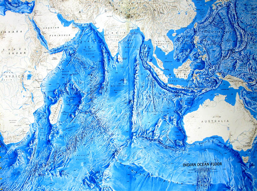
Bathymetric map of the Indian Ocean
The ocean's continental shelves are narrow, averaging 200 kilometres (125 mi) in width. An exception is found off Australia's western coast, where the shelf width exceeds 1,000 kilometres (600 mi). The average depth of the ocean is 3,890 metres (12,760 ft). Its deepest point, 7258 meters deep, is in the Java Trench.North of 50° south latitude, 86% of the main basin is covered by pelagic sediments, of which more than half is globigerina ooze. The remaining 14% is layered with terrigenous sediments. Glacial outwash dominates the extreme southern latitudes.
The major choke points include Bab el Mandeb, Strait of Hormuz, the Lombok Strait, the Strait of Malacca and the Palk Strait. Seas include Gulf of Aden, Andaman Sea, Arabian Sea, Bay of Bengal, Great Australian Bight, Laccadive Sea, Gulf of Mannar, Mozambique Channel, Gulf of Oman, Persian Gulf, Red Sea, and other tributary water bodies. It is artificially connected to the Mediterranean Sea via the Suez Canal, accessible via the Red Sea.


0 comments:
Post a Comment