
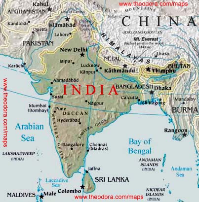
India political map shows the location of the 28 states and their capital cities. In a world map, India is located in South Asia along the geographical coordinates of 20º North latitude and 77º East longitude. The neighboring countries of India are Afghanistan, Pakistan, China, Nepal, Tibet, Bangladesh, Myanmar and Sri Lanka.
 |
| India political map(Click to Enlarge) |
Location of India
India political map shows in detail the states, capital cities as well as the bordering countries of India. India is located in southern Asia with Bay of Bengal on its eastern side and Arabian Sea on its western side. It is located on the geographical coordinates of 20º North and 77º East latitude and longitude, respectively. The country covers an area of about 3,287,590 sq km. Kanchenjunga, located at an elevation of 8,598 meters is the highest point of India. This country has got a long coastline of 7,000 km. India is surrounded by Afghanistan and Pakistan in the north-western side, China, Nepal and Tibet on the north-eastern side, Bangladesh and Myanmar in the eastern side and Sri Lanka in the southern side. The bordering countries are clearly shown on the India political map.Capital City: New Delhi-IndiaNew Delhi is located on the geographical coordinates of 28° 36' North latitude and 77° 12' East longitude. It is situated at an elevation of 210 meters above sea level. While Indira Gandhi International Airport is the airport in the city for international flights to India , domestic airports adjacent to the IGI Airport operate flights to other cities within India. Karol Bagh, Mahrauli, Palam, Kalkaji, Shakarpur and Paharganj are some of the city areas located in the Indian capital. New Delhi can be identified on the India Political Map by a yellow square. Indian States and Union Territories There are a total of 28 states and 7 Union Territories in India.
 |
| Map Of India |
The states of India along with their capital cities are as follows:
|
|
|
The Union Territories of India are:
- Chandigarh
- Daman and Diu
- Dadra and Nagar Haveli: Silvassa is the capital city.
- Lakshadweep: The capital city of this island is Kavaratti.
- Pondicherry
- National Capital Territory of Delhi
- Andaman and Nicobar Islands. The capital city of this island is Port Blair.
 |
| The Union Territories of India;Map |
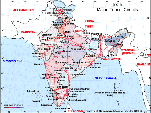
The states are highlighted on the political map of India with different colors. The state capitals are marked with a red circle on India map. Andaman and Nicobar Islands lies on the eastern side and Lakshadweep Island lies on the western side of India on the Bay of Bengal and the Arabian Sea respectively. Indian Ocean lies in the southern part of India. The water bodies are shown on the printable map of India by blue color. Each of the state on the map has different colors for making it convenient for the user. The national and the international boundary are represented by black colored dotted lines. Mapsofworld.com has a wide collection of maps of India. We offer maps of separate states of India including Rajasthan map, Gujarat map, Goa -India map and Tamilnadu map to mention a few. Blank India map and travel map of India are premium products at Mapsofworld.com. City maps like Mumbai -India map, Chennai map, and Kolkata map are also available at Mapsofworld.com. These maps combined together make a comprehensive India travel guide for those who've set out on India holidays and India vacations . Include all exotic locations in the country in your India tours and make use of the India travel map from Mapsofworld.com to make your tour a memorable one. Hotel Oberoi, Le Meridien, Taj Residency, Grand Inn Hotel, Maurya Sheraton, Shangri-La, etc. are a few of the prominent India hotels' chains.


0 comments:
Post a Comment