Indian Rivers Systems and Map


Indian Rivers Map

Rivers are an important part of Indian geography and Indian society. Most major cities in India are located by river banks, and their water provides much irrigation, transportation, livelihood and electricity throughout the country.
These rivers determine much of the course of action of India, as when they flood or dry up, everything is affected, for better or for worse. Some of these great rivers also have religious and mythological significance, and have been the site of many ancient societies.
All of India’s major rivers come from three main watersheds. The first is the Himalaya and Karakoram Ranges; the second is the Vindhya and Satpura Ranges; the third is the Sahyadri or Western Ghats region. Most rivers go into the Bay of Bengal, but some empty out into the Arabian Sea. There are a few major river networks in India, and then there are dozens of tributaries that flow off from them.

Indian River Systems
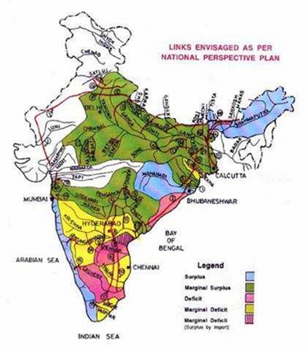
The Indus River System is mainly in Pakistan, but some of it is in India. the country of India derived its name from this river, and it is important in the country’s history and heritage. The ancient Indus Valley civilization thrived off of this river and its floodplain, which is one of the world’s oldest known civilizations. They built their settlements around its banks, and created an advanced drainage system for the water.
The river itself originates in Tibet, and is largely fed from the snow of the Himalayas. The Indus River is one of the few rivers in the world that has the sensation of tidal bore, which is when the incoming tidal water forms waves, and the waves travel up the river against the current.
The Brahmaputra River System starts off in Mansarovar Lake (in Tibet), and most of it is outside of India, flowing throughout Tibet and Bangladesh. It is common for this river to flood during monsoon season, which i s June through October, which often results in flash floods, deforestation and soil erosion. The Brahmaputra is one of the longest rivers in Asia.
The Narmada River System flows throughout central India. People associate the regions of North India and South India as dividing through this river. Its name in Sanskrit means “the Giver of Pleasure.” It runs from east to west, and empties into the Arabian Sea. It mostly flows throughout steep banks, so it is difficult to irrigate and navigate.
One famous spot on the Narmada River is Marble Rocks, a gorge in Bhedaghat (close to Jabalpur). These white limestone and basalt rocks are covered with green and black volcanic seams, and are fascinating to look at from a boat. Some of these rock formations reach up to 100 feet, while the river flows between them. The Narmada is also considered a holy river in India, in which one can be purified by washing in the waters.
The Tapti River System flows from east to west in central India. It originates in the Satpura Range, and then flows into the Gulf of Cambay of the Arabian Sea.
The Godavari River System has the second largest stretch of river within India, and its water appears to be brownish. It originates in Trimbakeshwar, which is near Mumbai, and empties into the Bay of Bengal. The river becomes very wide during monsoon season, and then mostly dries up during the winter. It is a sacred river to Hindus, and there are holy pilgrimages to the water, as well asreligious festivals held every 12 years.
The Krishna River System originates in Mahabaleswar and empties into the Bay of Bengal. It is located in central-southern India. Its name means “dark” in Sanskrit. It has one of the most fertile deltas in India, but it can get very dangerous and cause lots of damage during monsoon season, when it reaches over 75 feet in depth.
The Kaveri River System, or the Dakshin Ganga, has religious significance to Hindus. This river was also the water source for many ancient kingdoms in Southern India. It originates in the Western Ghats, and flows into the Bay of Bengal. Its basin is approximately 27,700 square miles. This is an important river, with a developed hydroelectric power system, and use for irrigation andconsumption. One important spot for hydroelectric power is ShivanasamudraFalls. These water falls were the source of the first hydroelectric power station in Asia.
The Mahanadi River System is a large delta that goes through much of India, and drains into the Bay of Bengal. Its source is hard to determine, because it comes from a network of different mountain streams. It has a high content of silt deposit, and it can cause deadly floods. Several hydroelectric power plants are powered by the Mahanadi River System. Its drainage area is an estimated 51,000 square miles.


Political Map Of India


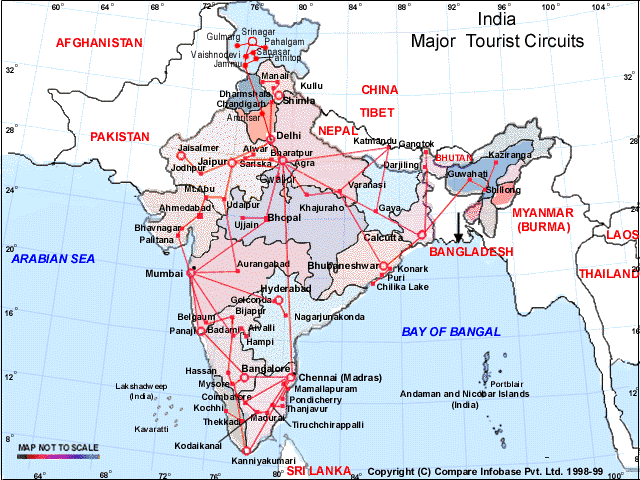
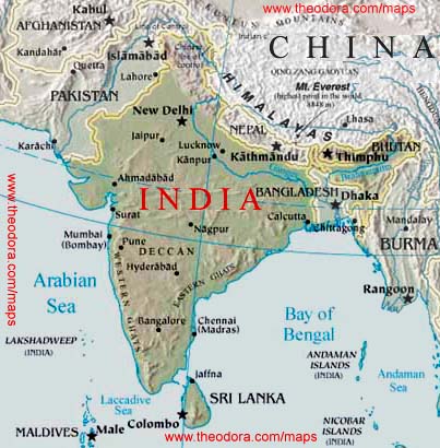
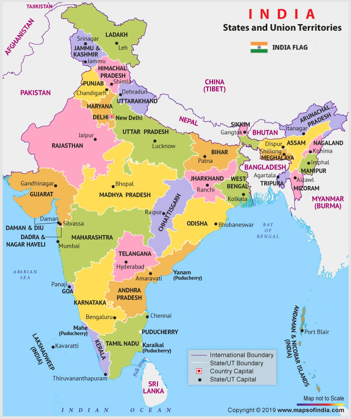
India political map shows the location of the 28 states and their capital cities. In a  world map, India   is located in South Asia along the geographical coordinates of 20º North latitude and 77º East longitude. The neighboring countries of India are Afghanistan, Pakistan, China, Nepal, Tibet, Bangladesh, Myanmar and Sri Lanka.
India political map(Click to Enlarge)


Location of India 

India political map   shows in detail the states, capital cities as well as the bordering countries of India. India is located in southern Asia with Bay of Bengal on its eastern side and Arabian Sea on its western side. It is located on the geographical coordinates of 20º North and 77º East latitude and longitude, respectively. The country covers an area of about 3,287,590 sq km. Kanchenjunga, located at an elevation of 8,598 meters is the highest point of India. This country has got a long coastline of 7,000 km. India is surrounded by Afghanistan and Pakistan in the north-western side, China, Nepal and Tibet on the north-eastern side, Bangladesh and Myanmar in the eastern side and Sri Lanka in the southern side. The bordering countries are clearly shown on the India political map.Capital City:  New Delhi-IndiaNew Delhi is located on the geographical coordinates of 28° 36' North latitude and 77° 12' East longitude. It is situated at an elevation of 210 meters above sea level. While Indira Gandhi International Airport is the airport in the city for international  flights to India  , domestic airports adjacent to the IGI Airport operate flights to other cities within India. Karol Bagh, Mahrauli, Palam, Kalkaji, Shakarpur and Paharganj are some of the city areas located in the Indian capital. New Delhi can be identified on the India Political Map by a yellow square. Indian States and Union Territories There are a total of 28 states and 7 Union Territories in India. 
Map Of India
The states of India along with their capital cities are as follows:
  • Jammu and Kashmir: Srinagar
  • Himachal Pradesh: Shimla
  • Punjab: Chandigarh
  • Uttaranchal: Dehradun
  • Haryana: Chandigarh
  • Rajasthan: Jaipur
  • Uttar Pradesh: Lucknow
  • Bihar: Patna
  • Sikkim: Gangtok
  • Assam: Dispur
  • Arunachal Pradesh: Itanagar
  • Manipur: Imphal
  • Nagaland: Kohima
  • Meghalaya: Shillong
  • Mizoram: Aizwal
  • Tripura: Agartala
  • West Bengal: Kolkata
  • Jharkhand: Ranchi
  • Madhya Pradesh: Bhopal
  • Chhattisgarh: Raipur
  • Gujarat: Gandhinagar
  • Orissa: Bhubaneshwar
  • Maharashtra: Mumbai
  • Andhra Pradesh: Hyderabad
  • Karnataka: Bangalore
  • Tamil Nadu: Chennai
  • Kerala: Thiruvananthapuram
  • Goa: Panaji
The Union Territories of India are:

  • Chandigarh
  • Daman and Diu
  • Dadra and Nagar Haveli: Silvassa is the capital city.
  • Lakshadweep: The capital city of this island is Kavaratti.
  • Pondicherry
  • National Capital Territory of Delhi
  • Andaman and Nicobar Islands. The capital city of this island is Port Blair.
The Union Territories of India;Map
    The states are highlighted on the political map of India with different colors. The state capitals are marked with a red circle on India map. Andaman and Nicobar Islands lies on the eastern side and Lakshadweep Island lies on the western side of India on the Bay of Bengal and the Arabian Sea respectively. Indian Ocean lies in the southern part of India. The water bodies are shown on the printable map of India by blue color. Each of the state on the map has different colors for making it convenient for the user. The national and the international boundary are represented by black colored dotted lines. Mapsofworld.com has a wide collection of maps of India. We offer maps of separate states of India including Rajasthan map, Gujarat map,  Goa -India map  and Tamilnadu map to mention a few.  Blank India map  and  travel map of India   are premium products at Mapsofworld.com. City maps like  Mumbai -India   map, Chennai map, and Kolkata map are also available at Mapsofworld.com. These maps combined together make a comprehensive   India travel guide   for those who've set out on  India holidays   and  India vacations  . Include all exotic locations in the country in your  India tours  and make use of the  India travel map   from Mapsofworld.com to make your tour a memorable one. Hotel Oberoi, Le Meridien, Taj Residency, Grand Inn Hotel, Maurya Sheraton, Shangri-La, etc. are a few of the prominent  India hotels'   chains.


    Indian Map


    Indian Map

    Map of India
    Indian Map
    India is in Southern Asia, bordering the Arabian Sea and the Bay of Bengal, between Burma and Pakistan known as the subcontinent. In the 19th century, Britain had assumed political control of virtually all Indian lands. Non-violent resistance to British colonialism led by Mohandas GANDHI and Jawaharlal NEHRU brought independence in 1947. The subcontinent was divided into the secular state of India and the smaller Muslim state of Pakistan. A third war between the two countries in 1971 resulted in East Pakistan becoming the separate nation of Bangladesh. With a population of some 1,027 million people, India is now the second country in the world, after China, to cross the one billion mark. The United Nations (UN) estimates that by 2050 India will have overtaken China as the most populous country in the world. Indians make up 16.7 per cent of the world’s population with an annual growth rate of close to two per cent. In 2001, India had 35 cities / urban areas with a population of more than one million people. In total, some 108 million Indians, or 10.5 per cent of the national population, live in the country’s 35 largest cities. Mumbai (Bombay) with a population of more than 16 million is now the world’s fourth-largest urban area followed by Kolkata (Calcutta) in fifth place.
    Andaman & Nicobar (U.T.), Lakshadweep (U.T.), Andhra Pradesh, Madhya Pradesh, Arunachal Pradesh, Maharashtra, Assam, Manipur, Bihar, Meghalaya, Chandigarh (U.T.), Mizoram, Chhattisgarh, Nagaland, Dadra & Nagar Haveli (U.T.), Orissa, Daman & Diu (U.T.), Pondicherry (U.T.), Delhi (U.T.-NCT), Punjab, Goa, Rajasthan, Gujarat, Sikkim, Haryana, Tamil Nadu, Himachal Pradesh, Tripura, Jammu & Kashmir, Uttar Pradesh, Jharkhand, Uttaranchal, Karnataka, West Bengal, Kerala
    Map of India


    Indian Ocean Map


    The Indian Ocean is the third largest of the world's oceanic divisions, covering approximately 20% of the water on the Earth's surface. It is bounded on the north by the Indian subcontinent; on the west by East Africa; on the east by Indochina, the Sunda Islands, and Australia; and on the south by the Southern Ocean (or, depending on definition, by Antarctica). The ocean is named after the geographic location called India.
    As one component of the interconnected global ocean, the Indian Ocean is delineated from the Atlantic Ocean by the 20° east meridian running south from Cape Agulhas, and from the Pacific by the meridian of 146°55' east. The northernmost extent of the Indian Ocean is approximately 30° north in the Persian Gulf. The Indian Ocean has asymmetric ocean circulation. This ocean is nearly 10,000 kilometres (6,200 mi) wide at the southern tips of Africa and Australia; its area is 73,556,000 square kilometres (28,350,000 sq mi), including the Red Sea and the Persian Gulf.
    The ocean's volume is estimated to be 292,131,000 cubic kilometres (70,086,000 mi3).Small islands dot the continental rims. Island nations within the ocean are Madagascar, the world's fourth largest island; Reunion Island; Comoros; Seychelles; Maldives; Mauritius; and Sri Lanka. The archipelago of Indonesia borders the ocean on the east.

    Climate

    The climate north of the equator is affected by a monsoon climate. Strong north-east winds blow from October until April; from May until October south and west winds prevail. In the Arabian Sea the violent Monsoon brings rain to the Indian subcontinent. In the southern hemisphere the winds are generally milder, but summer storms near Mauritius can be severe. When the monsoon winds change, cyclones sometimes strike the shores of the Arabian Sea and the Bay of Bengal. The Indian Ocean is the warmest ocean in the world.

    Hydrology

    Among the few large rivers flowing into the Indian Ocean are the Zambezi, Shatt al-Arab, Indus, Ganges, Brahmaputra, Jubba and Ayeyarwady River. Currents are mainly controlled by the monsoon. Two large circular currents, one in the northern hemisphere flowing clockwise and one south of the equator moving anticlockwise, constitute the dominant flow pattern. During the winter monsoon, however, currents in the north are reversed.
    Deep water circulation is controlled primarily by inflows from the Atlantic Ocean, the Red Sea, and Antarctic currents. North of 20° south latitude the minimum surface temperature is 22 °C (72 °F), exceeding 28 °C (82 °F) to the east. Southward of 40° south latitude, temperatures drop quickly.
    Surface water salinity ranges from 32 to 37 parts per 1000, the highest occurring in the Arabian Sea and in a belt between southern Africa and south-western Australia. Pack ice and icebergs are found throughout the year south of about 65° south latitude. The average northern limit of icebergs is 45° south latitude.

    Geography

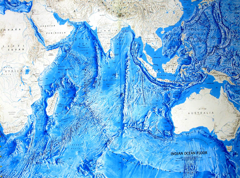
    Bathymetric map of the Indian Ocean
    The African, Indian, and Antarctic crustal plates converge in the Indian Ocean at the Rodrigues Triple Point. Their junctures are marked by branches of the mid-oceanic ridge forming an inverted Y, with the stem running south from the edge of the continental shelf near Mumbai, India. The eastern, western, and southern basins thus formed are subdivided into smaller basins by ridges.
    The ocean's continental shelves are narrow, averaging 200 kilometres (125 mi) in width. An exception is found off Australia's western coast, where the shelf width exceeds 1,000 kilometres (600 mi). The average depth of the ocean is 3,890 metres (12,760 ft). Its deepest point, 7258 meters deep, is in the Java Trench.North of 50° south latitude, 86% of the main basin is covered by pelagic sediments, of which more than half is globigerina ooze. The remaining 14% is layered with terrigenous sediments. Glacial outwash dominates the extreme southern latitudes.
    The major choke points include Bab el Mandeb, Strait of Hormuz, the Lombok Strait, the Strait of Malacca and the Palk Strait. Seas include Gulf of Aden, Andaman Sea, Arabian Sea, Bay of Bengal, Great Australian Bight, Laccadive Sea, Gulf of Mannar, Mozambique Channel, Gulf of Oman, Persian Gulf, Red Sea, and other tributary water bodies. It is artificially connected to the Mediterranean Sea via the Suez Canal, accessible via the Red Sea.


    VIDEO

    RECENT POSTS

    POPULAR POSTS


    Pak India Zone Copyright © 2011 LKart Theme Powered by Blogger